
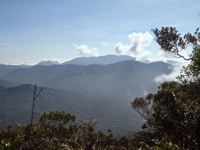
The lush and thick vegetation of the Malaysian rainforest floor.
On less trodden routes, one might even have to make their own trail through the thick vegetation. Though the mountains here don't see temperatures below zero, the fast changing mountain climate does pose a challenge. You could be trekking through the jungle floor in scorching hot and humid conditions only to be poured with torrential rain moments later at higher elevations. This drastic change in local climate and temperature can rapidly weaken a person's body hence causing him or her to easily fall sick. Not to forget the Malaysian rainforest is infested with blood sucking leaches which can suck up to 10X their original size! If you thought that by wearing anti-leach socks would solve the problem, you just thought wrong! Believe me that these sneaky creatures can some how find their way to the most delicate and private parts of your body!
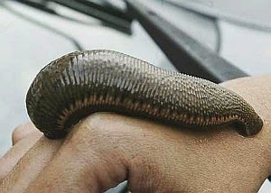
Blood thirsty leaches can suck up to 10 times their original size.
If you don't mind the leaches anyhow, I'm sure you will definitely mind the sandflies as their sting will cause a severe itch that can send you into a scratching frenzy the whole night long!

Sandfy bites are very itchy and leaves bad reddish scaring.
If you are lucky enough or should I say unlucky enough (depending on how you see it) to bump into the occasional tiger or elephant or snake or bear or a combination of them, you are just in for another run for your life encounter.

A wild Malayan tiger on the hunt.
So with this said, you probably will start to believe me that the G7's level of difficulty is indeed very misleading if you simply judged it based on its elevation.
The following is a brief description of all the G7 mountains according to their elevation and degree of difficulty:
Gunung Tahan (2187m) G1
Difficulty Rank 4.5/5 from Kuala Tahan 4/5 from Merapoh

Mount Tahan is the highest of the G7 mountains which also means its the highest peak in Peninsular Malaysia. It is located right in the heart of Taman Negara (Malaysia's largest National Park) which is claimed to be the oldest rainforest in the world. The word "Tahan" literally means endurance in Malay. As its name suggest, only those who can endure the long and arduous journey through its thick rainforest terrain can make it to the top. The name itself strikes fear in those who are seeking to conquer its summit. Mount Tahan is the only G7 mountain located outside of the Titiwangsa Main range which forms the back bone of Peninsular Malaysia. In fact, Mount Tahan is located in the Tahan Range which is part of the Tenasserim Range that stretches all the way from Southern Thailand. There are two main routes that lead to the summit of this mountain namely the Kuala Tahan trail and the Merapoh trail. The former typically takes a week long while the latter takes between 3-5 days. It is also possible to start in Kuala Tahan and end in Merapoh and vice versa. The National Park is usually closed during the Northeast monsoon period (Nov-Feb) as heavy rain causes flooding. The degree of difficulty of this mountain depends on which trail is used. The Kuala Tahan route is certainly the more challenging one as it is longer in distance and crosses through several of Taman Negara's major rivers. This route is only recommended for very fit and experienced hikers. Meanwhile the Merapoh route is shorter but goes up the steeper section of the mountain. Overall, a high level of fitness is required to attempt Mount Tahan.
Gunung Korbu (2183m) G2
Difficulty Rank 4.5/5

Mount Korbu is certainly no easy pushover. Just gazing at its steepness and massiveness might make you wanna turn back at the trailhead. This hell of a mountain promises to give you a hell of an experience! Just getting to the mountain itself is already a challenge as you will need to traverse through thick rainforest in challenging terrain. In the low lying areas where the ground is more wet, you will notice vampire leaches chasing after you. By half way point your legs would be bloodily stained by leach bites. At mid way point, you are bound to be bitten by "invisible" sandflies which will result in a nastily itchy sting that gets you scratching all night long. The worst sandfly zone is at Kem Agas (aka Kem Kijang) which happens to be the 2nd camp site. Just when you thought things might get better, you are proven wrong when you stand face to face with the Chuban Wall which is a near vertical cliff on the mountain and undoubtedly the most challenging part of the trek! The Chuban Wall is what defines Korbu hence climbing up this challenging section is certainly a "Baptism of Fire" for any potential Korbu sumitteer. There are fixed ropes to assist hikers in climbing up the Chuban Wall however they are poorly maintained and have not been replaced in a long time. Those who have acrophobia (fear of heights) will find it hard to get past this section as the view of a 1000m drop is exposed here. Once passed this section, there are 2 more false peaks to get passed before reaching Korbu's summit which is the 2nd highest in Peninsular Malaysia. From here, you could continue onwards to Gayong's summit for another 1 hour through a flat ridge that connects the two mountains.
Gunung Yong Belar (2181m) G3
Difficulty Rank 3/5 from Cameron Highlands 4.5/5 from Gayong

Yong Belar makes up one of the three mountains of the Trans Titiwangsa trail. This trail is a very popular trail that crosses the Titiwangsa Main Range as the name suggests. Traditionally the trail start from Mount Korbu onward to Mount Gayong and Mount Yong Belar before ending in the Blue Valley of the Cameron Highlands. It is also possible to do a reverse of that trail starting in Yong Belar and ending up in Korbu. Although there are no big challenges posed by Yong Belar, one cannot take it for granted. There are many reports by hikers of encounters with wild animals such as elephants, snakes and wildboars on this mountain. There is a point on this mountain called "Three Boundaries" because it is the exact point where the boundaries of the three states namely Pahang, Perak and Kelantan meet. This point is marked by a stone marker to denote the significance of that place. The start of the journey to Yong Belar through the Blue Valley is very scenic. This valley is located at the very edge of the Cameron Highlands just about where the trailhead to Yong Belar is.
Gunung Gayong (2173m) G4
Difficulty Rank 2/5 from Korbu 4.5/5 from Yong Belar

Gunung Gayong is also known as the birthplace of "silat gayong" a traditional Malay martial art. This mountain is basically Malaysia's version of the Shaolin Monastry sans the temple and the monks. Legend has it that there was once a mysterious Malay warrior who went up to the summit of Gayong to meditate for one year. In the process he invented "silat gayong" to defend himself from the wild animals that inhabit the mountain. This mountain has a very broad peak which looks like a turtle from afar. No wonder it is a suitable place to practice martial arts given sufficient flat surface on the peak. The view from its peak is magnificent as one will be able to see Mount Korbu in all its glory. To get to Gayong's summit, you will first have to summit either Korbu or Yong Belar as Gayong is located right in the middle of these two mountains. The route from Korbu will be the easier option as it is connected by a relatively flat and easy ridge to hike. This is the reason I ranked this mountain as the easiest of the G7 but don't get deceived by this rank as you will have to conquer either Korbu or Yong Belar first to get here. The route from Yong Belar goes through a valley called "Lembah H2O" so named because it is muddy and is strewn with puddles of water the entire trail. What this also means is that you will be trekking through leach territory although the consolation will be being able to find water source easily. This route is very difficult hence requiring a high level of fitness and is indeed the toughest part of the Trans Titiwangsa trail.
Gunung Chamah (2171m) G5
Difficulty Rank 5/5
Located in the middle of the Royal Belum forest, this is undoubtedly the toughest G7 mountain to conquer simply because the route that leads to its peak is through thick virgin rainforest. It is so remote that if you were to trek out of Chamah it would take no less than 4 solid days of non stop trekking through the rainforest. The Royal Belum forest is also famous for wild tiger and elephant sightings and stumbling upon tiger footprints is quite common. The risk of getting lost in the virgin jungle is very real hence it is always wise to get an experienced guide and stick together with the hiking convoy as trails can sometimes be very undefined. A good 4 days of trekking is usually spend getting to the mountain itself due to its remoteness. On the mountain proper, there are several false peaks that lies along the way and this can be very demoralizing. Unfortunately, the summit lies at the very end of the ridge of false peaks. This mountain should only be attempted by hikers who have very high levels of fitness because the many provisions that you would have to carry for the long expedition will make your backpack very heavy. It is also recommended that you register with the nearest police station in Gua Musang so that the authorities are aware on the expected duration you will be in the jungle (in case they need to conduct a search and rescue operation). Typically this mountain is attempted along with Ulu Sepat in what is called the Trans Chamah-Ulu Sepat trail and can take between 7-10 days long depending on fitness. This mountain is usually left as the last one on the G7 list because it is better to gain some G7 experience from the easier lot of the G7s.
Gunung Yong Yap (2167m) G6
Difficulty Rank 3.5/5

Yong Yap is a pyramidal shaped mountain. It is undoubtedly the most symmetrical mountain in Malaysia. From afar, it has a very sharp pointed peak. To get to the trailhead of this mountain one would need to ride in a 4WD vehicle from the starting point in Kampung Lasah orang asli village (takes 2 hours) or from Pos Brooke (takes 40 minutes). This is a very bumpy ride as it goes through the old logging trail which is untared and muddy. This ride will save you a lot of trekking energy as you wont need to trek through the rainforest to get to the mountain proper however if you happen to get car sick then it doesn't help your cause. Once you are dropped off the 4WD, the trek starts and the route is practically heading all the way up! Your calf muscles will have to be very strong to endure this long and steep uphill trek. The trek downhill can be very punishing as it can take a toll on your knees. The jungles of the Yong Yap area is one of the few places where the Malayan Tiger still roams freely. There have been cases of tiger attacks on this mountain in the past. The two fatal ones that I can recall was a lone logger who was attacked while walking on the logging trail and another case involving an Orang Asli (aborigine) being devoured by a hungry old tiger. It is advisable to stay within the group at all times and avoid straying alone in the jungle here.
Gunung Ulu Sepat (2161m) G7
Difficulty Rank 4/5

The last of the G7 but not necessarily the easiest. Also located in the Royal Belum forest, this mountain is as remote as Mount Chamah. Typically hikers would do a Trans Chamah-Ulu Sepat to bag two peaks in one trip. But make no mistake, this trail is one of the most difficult mountain treks in the entire Malaysia if not the most difficult! Getting to this mountain itself is a major hurdle as you would have to travel a long way just to reach the trailhead. There are two ways to reach the trailhead which is located at Pos Kemar. The first way is by riding a 4WD from Sungai Siput to Kampung Lerlar while the 2nd way is by taking a boat across the Temenggor Lake from Grik's Trojan Jetty to Pos Kemar Jetty (1 hour) or alternatively from the Banding Jetty to Pos Kemar Jetty (2 hours). From the Pos Kemar Jetty, you will require a 4WD to get to the trailhead at Pos Kemar. Travelling here is already an adventure by itself. This mountain is also well renowned for its little menace "sandflies" and hikers coming here are quite unlikely to get away unscathed by these nasty creatures. Dont be surprised if you see elephants climbing along the way as the slopes of this mountain are rather gentle at certain points. As you approach the summit, the gradient can be very steep and you might even have to scramble on all four at certain points as it is near vertical.
*Disclaimer: These descriptions are merely the opinions and judgement of the author and should not be taken as an official benchmark as fitness level and hiking experience of each person varies from one to another. All the G7 mountains should be treated with utmost respect as they certainly demand a high degree of fitness for anyone planning to attempt it!

3 comments:
Hello,
Thanks for your write up on the G7 mountains. I've been looking to start hiking some of them.
Just wondering if you went on your own (with GPS or...?) or did you have a guide that knew the trail well?
Thanks :)
TEBING TINGGI BACKPACK(FB)
MOUNT GUIDE SERVICE LICENCED TG9624(base at cameroon highland)
Will arrange:
-forestry permit
-police report
-nature guide
-emergency kit(basic)
-walkie talkie
-4x4 transport to trailhead
ANDY
017-9997790
whataps/call/sms
i love the scenes i would love to go there with my best peoples as i want to go to these places check highest mountains you will love it for sure
Post a Comment